German Tsunami Early Warning System Takes Shape
November 16, 2005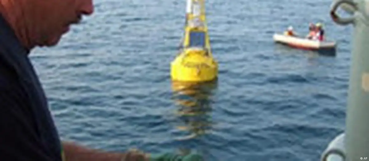
Amid the endless blue of the Indian Ocean and to the clicking of media cameras, German and Indonesian scientists aboard the research vessel "Sonne" (sun), this week released the first of a host of bright yellow buoys off the coast of Indonesia.
"At 4:30 pm, under sunny skies and ideal weather conditions, one of the two GITEWS [German-Indonesian Tsunami Early Warning System] buoys was released at the entrance to the Sunda Strait," wrote Ernst Flüh, a geophysicist who works at the Leibniz Institute of Marine Sciences at the University of Kiel and who is one of the scientists aboard the research vessel, in a Web log for Deutsche Welle.
Part of a German-financed flagship tsunami early warning system, the high-tech project which cost some 45 million euros ($52 million) is headed by the Potsdam-based Geo Research Center along with half a dozen other German research institutes.
The buoy released as a test project on Tuesday is meant to find a final anchoring place this week and will be followed by a second one by the end of the month -- in time for the first anniversary of the tsunami catastrophe on Dec 26 last year, which killed some 220,000 people around the Indian Ocean.
Fast and efficient
The high-tech yellow buoys, which weigh about three tons each and cost 300,000 euros apiece, are designed to avert the large-scale disaster wreaked by last year's tsunami by alarming thousands of people of imminent killer waves in future.
That would be achieved through interplay between about 10 of the special GPS buoys, pressure sensors embedded on the ocean floor and measuring devices for earthquakes and water levels on land. That information would in turn be fed to observation stations on the coast, which could then gauge the danger level.
The system is believed to be superior to the existing US model in the Pacific, as it is able to identify more accurately the tsunami waves that are often triggered by earthquakes. Experts say the system is faster and more efficient, thus reducing the number of false alarms.
"In seven or eight minutes we can process the data in order to be able to say with certainty whether a tsunami has erupted," Jörn Lauterjung, head of the project told news agency dpa.
"Dangerous, seismological zone"
One of the challenges facing scientists aboard the research vessel "Sonne" is to determine where exactly the buoys should be released.
Accurate information about the makeup of the ocean bed is hard to get and over the past weeks, researchers have been trying to assess it onboard their ship, and feeding the findings to computer graphics program.
The result has been graphic images of gigantic, jagged underwater mountain ranges with staggeringly different heights, spanning thousands of meters where the Eurasian and Indo Australian plates meet and make up the notorious Sunda Straits.
That's exactly where a massive build-up of energy is believed to have taken place, which first sparked an earthquake near the northern tip of Sumatra, in turn triggering the tsunami last December.
"The Sunda Straits is one of the most dangerous seismological zones of the world," Lauterjung said.
That's the reason the scientists have decided to concentrate on the region. In particular, they plan to follow the course of the straits southwards where experts fear pent-up energy on overlapping plates still hasn't been released -- something, they say, could have deadly consequences.
Scientists plan to work up north to Banda Aceh after the Sunda Straits. But the project is not expected to be completely finished and functioning until 2008.
It's hoped that will provide enough time to train Indonesian experts in the new system.